
ZIP Code Tabulation Area Map Archive
More current maps are available on IndianaMap and the ZIP Code maps page.
ZIP Code Tabulation Areas (ZCTAs) are the Census Bureau's generalized representations of U.S. Postal Service ZIP Codes, created by aggregating census blocks. STATS Indiana provides maps of Indiana by region, congressional district or statewide.
Note: Unless otherwise noted, our outputs are based on TIGER/Line 2006 data; however, bear in mind that these files only include ZIP codes current as of October 2002.
Statewide Maps
- Large-Scale Indiana ZCTA Map (7MB)
- Three-Digit ZCTA Map (based on 2000 cartographic boundary files)
Regional Maps
These easy-to-use and view ZCTA outline maps, in PDF format show interstates, as well as cities and towns. Select a region using the following selection box.
Counties in Each Regional Map
- Northwest: Benton, Carroll, Cass, Fulton, Jasper, La Porte, Lake, Marshall, Newton, Porter, Pulaski, St. Joseph, Starke, White
- Northeast: Adams, Allen, Blackford, De Kalb, Elkhart, Grant, Huntington, Jay, Kosciusko, Lagrange, Miami, Noble, Steuben, Wabash, Wells, Whitley
- East Central: Decatur, Delaware, Fayette, Franklin, Hamilton, Hancock, Henry, Howard, Johnson, Madison, Marion, Randolph, Rush, Shelby, Tipton, Union, Wayne
- West Central: Boone, Clay, Clinton, Fountain, Hendricks, Montgomery, Morgan, Owen, Parke, Putnam, Tippecanoe, Vermillion, Vigo, Warren
- Southwest: Crawford, Daviess, Dubois, Gibson, Greene, Knox, Lawrence, Martin, Monroe, Orange, Perry, Pike, Posey, Spencer, Sullivan, Vanderburgh, Warrick
- Southeast: Bartholomew, Brown, Clark, Dearborn, Floyd, Harrison, Jackson, Jefferson, Jennings, Ohio, Ripley, Scott, Switzerland, Washington
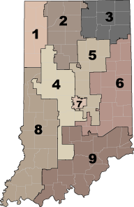
U.S. Congressional District Maps
See which ZCTAs fall within the individual congressional districts by selecting a district from the map below (based on 2000 cartographic boundary files). Want to download all the districts at once? Click here to access a pdf with all 9 districts (1 MB).
Note about ZCTAs ending with XX or HH
The three-digit ZCTA code and an "XX" suffix are applied to a large land area (generally larger than 25 square miles) where we had insufficient information to determine the five-digit codes. The USPS may not provide five-digit ZIP Code delivery service in this area. These are generally rural areas with little settlement; for example, parks, forest lands, and desert and mountainous areas. Smaller areas were generally absorbed into adjacent five-digit ZCTAs, but for larger areas, we did not want to overextend the surrounding five-digit ZCTAs.
The requirements for ZCTA delineation state that all census blocks receive a ZCTA code. Because large water features may border many five-digit ZCTAs, it would be difficult to divide up the water features and assign the parts to the five-digit ZCTAs on the land. Furthermore, any attempt to add these water features to land-based ZCTAs, would greatly distort the size and shape of the land ZCTAs, particularly in coastal areas. To avoid these problems, such water features receive ZCTA codes ending in "HH" (special code for hydrographic features).